 CUBE ChatShaala — Session Summary
Date: 28 April 2026 | Topic: Geography, Coordinates & Photoperiodism
Discussion Summary
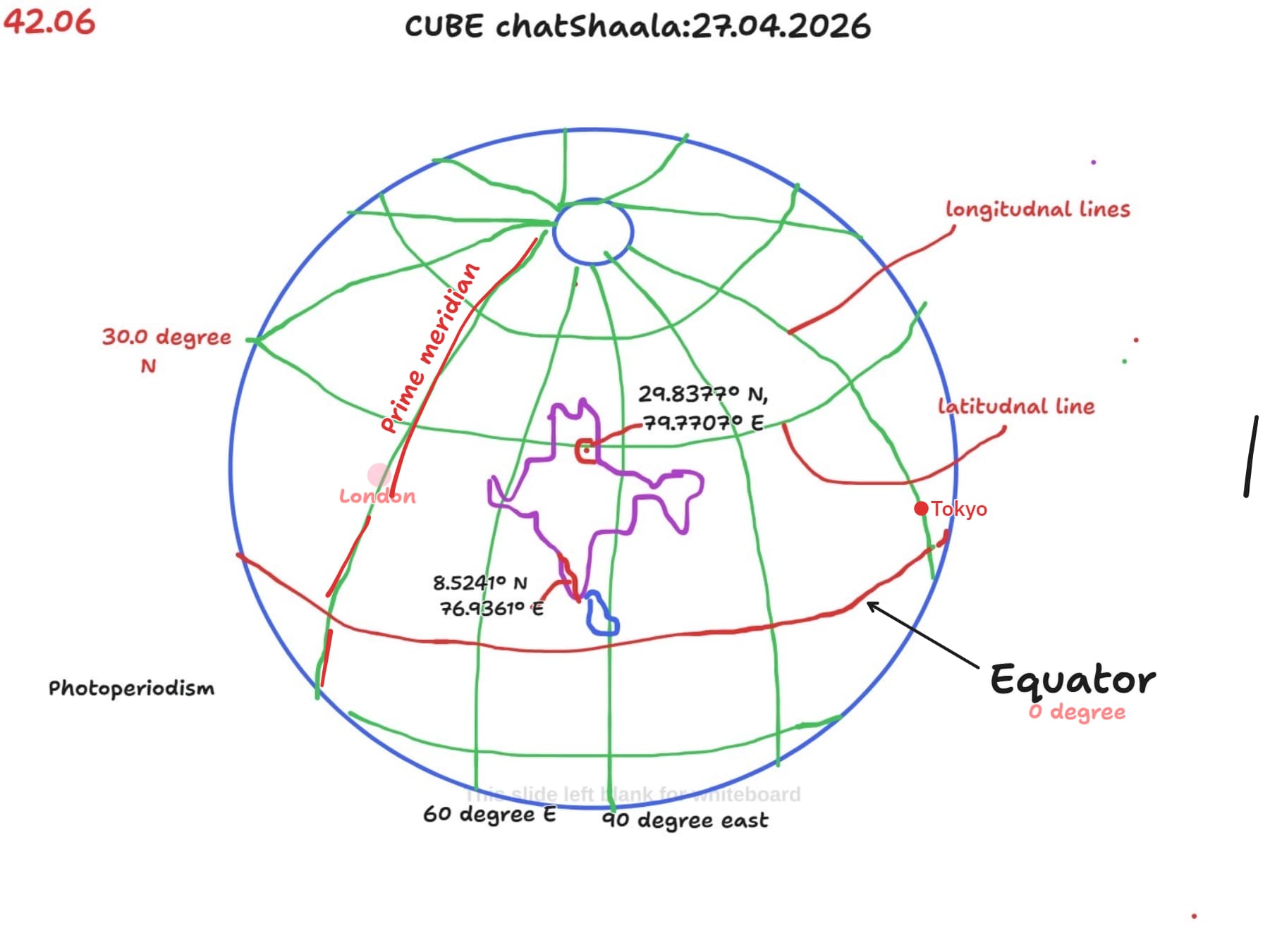
The session opened with a hand-drawn globe on the whiteboard, which immediately set the tone for a geography-grounded discussion. Participants collaboratively identified and labelled key reference lines — the Equator (0°), the Prime Meridian, and several latitudinal and longitudinal lines — before moving into a more applied discussion about real geographical coordinates.
Reference lines and their meaning
The group discussed how the Earth is divided into a coordinate grid. Longitudinal lines run north–south from pole to pole, and their reference 0° passes through Greenwich, a borough of London, established as the Prime Meridian in 1851. Latitudinal lines run east–west parallel to the Equator, which sits at 0° and divides the globe into the Northern and Southern hemispheres. These were all annotated directly on the whiteboard globe, with London marked near the Prime Meridian and Tokyo visible near the east.
Locating places using coordinates
Two specific Indian locations were highlighted during the session:
Location 1 — Bageshwar, Uttarakhand
29.8377° N, 79.7707° E — A hill district in the Kumaon region of Uttarakhand, located in northern India at approximately 30° N latitude. The discussion noted that Bageshwar is located at a significantly higher latitude than peninsular India, which directly influences its climate: cooler winters (average temperature around 11 °C in January), warm summers peaking at around 27–38 °C in June, and heavy monsoon rainfall (~330 mm in July alone).
Location 2 — Thiruvananthapuram, Kerala
8.5241° N, 76.9361° E — The capital of Kerala, situated near the extreme southern tip of mainland India on the west coast, close to the Arabian Sea. Its low latitude (~8.5° N) means it receives nearly direct overhead sunlight for much of the year, resulting in a warm tropical climate with less seasonal temperature variation compared to Bageshwar.
The contrast between these two locations formed the crux of the discussion: why does Bageshwar experience such extreme seasonal temperature shifts while Thiruvananthapuram remains relatively warm year-round? The answer, the group agreed, lies in latitude and the angle of incoming solar radiation.
Latitude and temperature: the solar angle argument
Participants explored how locations closer to the Equator receive more direct, concentrated sunlight. In contrast, locations at higher latitudes receive sunlight at a shallower angle, spread over a larger surface area, and therefore receive less intense sunlight. This explains why Thiruvananthapuram (~8.5° N) is consistently warm, while Bageshwar (~30° N) has much colder winters and hotter, shorter summers.
Photoperiodism — a bridge to biology
The word “Photoperiodism” was written on the bottom-left of the whiteboard, signalling that the discussion was heading towards biology. Photoperiodism refers to an organism’s physiological response to the length of day (and night) — a phenomenon directly linked to latitude. At higher latitudes like Bageshwar, the difference in day length between summer and winter is dramatic. Near the Equator (like Thiruvananthapuram), day length stays close to 12 hours throughout the year. This differential in photoperiod influences flowering in plants, reproductive cycles in animals, and seasonal behaviour across organisms — making it a key concept for the CUBE research community.
 Provocative Questions
-
Thiruvananthapuram is at ~8.5° N and Bageshwar at ~30° N. If you were conducting a photoperiodism experiment with the same plant species at both locations simultaneously, what differences in flowering time would you predict, and why?
-
The Prime Meridian passes through London (near 0° longitude). Tokyo is far to the east (~140° E). How does this longitudinal difference translate into a time difference, and does longitude affect photoperiod in the same way that latitude does?
-
Bageshwar records its highest average rainfall in July (~330 mm), while its hottest temperatures occur in June. What does this tell us about the relationship between the monsoon and the solar angle at that latitude? Does the arrival of clouds and rain affect day length as experienced by plants?
-
If a CUBE researcher in Thiruvananthapuram and one in Bageshwar both observe their model organism (say, Drosophila or a short-day plant) on the same calendar date, will they be observing it under the same photoperiodic conditions? What does this mean for reproducibility in distributed CUBE experiments?
-
The Equator is at 0° latitude and receives the most direct sunlight. Does this mean that organisms living at the Equator are effectively “exempt” from photoperiodism? Or do even small seasonal changes in day length matter biologically?
 What I Have Learned
-
Coordinates are not just addresses — they carry ecological information. Knowing that Thiruvananthapuram is at 8.5° N and Bageshwar is at 30° N immediately tells you something about the climate, the seasons, and how living things there respond to light.
-
The Prime Meridian is a human convention, but latitude is a physical reality. Longitude is an agreed-upon grid for navigation; latitude, however, determines the actual angle of sunlight and therefore drives temperature and photoperiod differences that are real and measurable.
-
Photoperiodism connects astronomy to biology. The reason plants flower at specific times of year is ultimately because the Earth is tilted on its axis and orbits the Sun — a fact that shows up clearly when you compare two CUBE locations at very different latitudes.
-
Distributed science requires geographic awareness. When CUBE researchers across India conduct the same experiment, they must account for where they are on the map. The same date does not mean the same conditions.
-
Visualising the globe helps. Drawing the Earth, placing cities, tracing the Prime Meridian and Equator — this made the abstract concept of coordinates feel concrete and navigable.
 TINKE Moments (This I Never Knew Earlier)
TINKE 1
Many participants assumed that if two cities are in the same country (like Thiruvananthapuram and Bageshwar, both in India), they would experience roughly similar climates. The coordinate comparison showed this is far from true — a 21° difference in latitude produces dramatically different temperature ranges, monsoon intensities, and photoperiods.
TINKE 2
The Prime Meridian’s placement through Greenwich, London, is not a geographical necessity — it is a historical and political convention, formalised in 1851. Before it was standardised, different countries used their own prime meridians. This raises an interesting question: would biology care if we renumbered the longitudes?
TINKE 3
Bageshwar can reach temperatures as high as 38 °C in early June, yet it is a Himalayan hill town. The assumption that “hill = always cold” is a misconception — pre-monsoon June brings dry, intense heat even at 30° N before the cloud cover of July cools things down through rainfall.
TINKE 4
Photoperiodism is not just about plants — it governs reproductive timing, migration, and seasonal behaviour in animals too. Yet many biology students associate it almost exclusively with flowering. The connection between day length and, say, Drosophila behaviour or even human circadian biology was a new bridge for several participants.
 Gaps and Misconceptions
Gap 1 — Confusing longitude with time zones only
Several participants instinctively associated longitude only with time zones, not with the position of a location relative to the Sun during the day. While longitude determines time zone, it does not significantly affect photoperiod (day length), which is primarily a function of latitude and season. This distinction was not fully resolved in the session and deserves a dedicated follow-up.
Gap 2 — Photoperiodism is left underexplored
Although “Photoperiodism” was written on the board, the discussion did not go deep into the critical day length, the role of phytochrome, or specific examples from CUBE model organisms. This appears to be an intentional hook for the next session, but participants may benefit from a bridging reading before the follow-up.
Misconception — “Equator = always hottest”
A common misconception is that the Equator is always the hottest region on Earth. In reality, temperature depends on altitude, ocean currents, and land cover as well. Parts of the Andes and East Africa that lie on or near the Equator are cool because of their elevation. Latitude sets the solar angle, but it is not the only variable in temperature.
Misconception — “India has a uniform latitude.”
Because India is typically seen as a single country on maps, students often underestimate the range of latitudes it spans — roughly from 8° N (Kanyakumari) to 37° N (Ladakh). This session helped concretise that range by anchoring it to two real CUBE-relevant cities.
 Photograph during Chatshaala

 Referance